World's least seaworthy kayak. This is what I traded my old engine for.
Hmm....
Wednesday, July 29, 2009

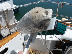
Johny's bottom scrubber
Its a broom and a long piece of PVC pipe. The fender keeps it pushed up against the hull. Works very nicely.
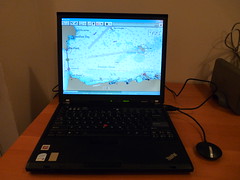
Chartplotting on a budget
I've just bought a "GlobalSat BU-353 WaterProof USB GPS Receiver (SiRF Star III)" for $36.95 from Amazon. Its smaller than it looks online, comes with an optional suction cup and also has a magnetic base that will hold it onto things as small as a screw. I couldn't get reception in my office (there's a floor above mine) but worked great in my home.
I've installed OpenCPN from:
http://bigdumboat.com/cpnindex.html
http://opencpn.sourceforge.net/
which is a free open source chart plotter and will load raster charts from:
http://www.nauticalcharts.noaa.gov/mcd/Raster/index.htm
and vector charts from:
http://www.nauticalcharts.noaa.gov/mcd/enc/index.htm
I downloaded the entire set of NOAA vector charts in about an hour and they take up about 1Gb when uncompressed.
I had to tell OpenCPN which COM port the GPS was on, tell it the directory where the charts I downloaded where and then wait a couple of minutes while it digested them.
All in all, pretty painless.
Its got some nice features:
Couple this with a $300 netbook and your boat's got a battle computer.
Update: NOAA's got a new site for downloading charts -- http://www.charts.noaa.gov
Its pretty slick and lets you download packs of charts by state.
I've installed OpenCPN from:
http://bigdumboat.com/cpnindex.html
http://opencpn.sourceforge.net/
which is a free open source chart plotter and will load raster charts from:
http://www.nauticalcharts.noaa.gov/mcd/Raster/index.htm
and vector charts from:
http://www.nauticalcharts.noaa.gov/mcd/enc/index.htm
I downloaded the entire set of NOAA vector charts in about an hour and they take up about 1Gb when uncompressed.
I had to tell OpenCPN which COM port the GPS was on, tell it the directory where the charts I downloaded where and then wait a couple of minutes while it digested them.
All in all, pretty painless.
Its got some nice features:
- displays plots of tidal information for all NOAA substations for any time
- can read from NEMA AIS receivers and allows you to setup collision alarms.
- can add waypoints to the chart and transmit directions to a NEMA autopilot
- easy switching between different charts at different scales.
- night mode color scheme
- free
- cross platform. Runs the same in Linux, WindowsXP, Vista and OSX.
- I don't see a way to save the waypoints, record tracks or any other information
- MOB mode
- anchor alarm
- AIS via internet
- satellite imagery overlays
- support for GRIB overlays
- anti-aliased scaling of the raster charts. They look very bad when zoomed out.
- its supposed to also have support for currents, although the display
- for that is a little screwed up in the current release.
- radar overlays
Couple this with a $300 netbook and your boat's got a battle computer.
Update: NOAA's got a new site for downloading charts -- http://www.charts.noaa.gov
Its pretty slick and lets you download packs of charts by state.
Saturday, July 25, 2009
New engine woes?
We've been having some problems starting the new engine. There have been a couple of times when we needed to run the lift pump to clear air in the fuel lines to get it started. Today the engine cut out and later refused restart. I recently installed a charging relay for the batteries and thought the batteries could be to blame. The starter was turned over. Volts at the engine read 12.6 which is normal.
Finally, Wendy suggested that the tank might be empty. We added a gallon from the reserve tank and she fired straight up. Doh!
Can't be sure whether the tank was empty -- the fuel gauge read 3/4 full. However, it has read the same since it was installed. Will know for sure when we fuel up next week.
Saturday, July 18, 2009
Day out on the Gold Star

Subscribe to:
Posts (Atom)