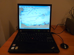
I've installed OpenCPN from:
http://bigdumboat.com/cpnindex.html
http://opencpn.sourceforge.net/
which is a free open source chart plotter and will load raster charts from:
http://www.nauticalcharts.noaa.gov/mcd/Raster/index.htm
and vector charts from:
http://www.nauticalcharts.noaa.gov/mcd/enc/index.htm
I downloaded the entire set of NOAA vector charts in about an hour and they take up about 1Gb when uncompressed.
I had to tell OpenCPN which COM port the GPS was on, tell it the directory where the charts I downloaded where and then wait a couple of minutes while it digested them.
All in all, pretty painless.
Its got some nice features:
- displays plots of tidal information for all NOAA substations for any time
- can read from NEMA AIS receivers and allows you to setup collision alarms.
- can add waypoints to the chart and transmit directions to a NEMA autopilot
- easy switching between different charts at different scales.
- night mode color scheme
- free
- cross platform. Runs the same in Linux, WindowsXP, Vista and OSX.
- I don't see a way to save the waypoints, record tracks or any other information
- MOB mode
- anchor alarm
- AIS via internet
- satellite imagery overlays
- support for GRIB overlays
- anti-aliased scaling of the raster charts. They look very bad when zoomed out.
- its supposed to also have support for currents, although the display
- for that is a little screwed up in the current release.
- radar overlays
Couple this with a $300 netbook and your boat's got a battle computer.
Update: NOAA's got a new site for downloading charts -- http://www.charts.noaa.gov
Its pretty slick and lets you download packs of charts by state.
2 comments:
I gave openCPN a shot on my mac, it's *really* buggy, and pretty awful to use. Props to a opensource chart plotter software, but it has a ways to go to catch up to MacENC on the OS X platform. I do dig the new NOAA chart download by state function, thanks for the pointer.
You can save waypoints by using the Export GPX button. It's hidden by default but can be made visible by going to the ToolBox-Etc.-Show GPX Icons. You can also save by right clicking on the track and choosing Export GPX.
Post a Comment